
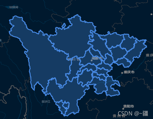
加载1个或多个要素
<template>
  <div id="map" style="width: 100vw; height: 100vh"></div>
</template>
<script>
import "ol/ol.css";
import TileLayer from "ol/layer/Tile";
import VectorLayer from "ol/layer/Vector";
import VectorSource from "ol/source/Vector";
import XYZ from "ol/source/XYZ";
import { Map, View, Feature, ol } from "ol";
import { Style, Stroke, Fill } from "ol/style";
import { Polygon, MultiPolygon } from "ol/geom";

import areaGeo from "@/assets/chengdu.json";

export default {
  data() {
    return {
      map: {},
      areaLayer: {},
    };
  },
  mounted() {
    this.initMap(); //初始化地图方法
    this.addArea(areaGeo); //添加区域图层方法
    this.pointMove();
    this.getFeatureByClick();
  },
  methods: {
    pointMove() {
      // 设置鼠标划过矢量要素的样式
      this.map.on("pointermove", (e) => {
        const isHover = this.map.hasFeatureAtPixel(e.pixel);
        this.map.getTargetElement().style.cursor = isHover ? "pointer" : "";
      });
    },
    getFeatureByClick() {
      this.map.on("click", (e) => {
        let features = this.map.getFeaturesAtPixel(e.pixel);
        this.map.getView().fit(features[0].getGeometry(), {
          duration: 1500,
          padding: [100, 100, 100, 100],
        });
      });
    },
    /**
     * 设置区域
     */
    addArea(geo = {}) {
      if (Object.keys(geo).length == 0 && geo.features.length == 0) return;

      // 设置图层
      this.areaLayer = new VectorLayer({
        source: new VectorSource({
          features: [],
        }),
      });
      // 添加图层
      this.map.addLayer(this.areaLayer);

      let features = geo.features;

      for (let i in features) {
        let areaFeature = {};

        if (features[i].geometry.type == "MultiPolygon") {
          areaFeature = new Feature({
            geometry: new MultiPolygon(features[i].geometry.coordinates),
          });
        } else if (features[i].geometry.type == "Polygon") {
          areaFeature = new Feature({
            geometry: new Polygon(features[i].geometry.coordinates),
          });
        }
        areaFeature.setStyle(
          new Style({
            fill: new Fill({ color: "#4e98f444" }),
            stroke: new Stroke({
              width: 3,
              color: [71, 137, 227, 1],
            }),
          })
        );
        areaFeature.setProperties(features[i].properties);
        this.areaLayer.getSource().addFeature(areaFeature);
      }
    },
    /**
     * 初始化地图
     */
    initMap() {
      this.map = new Map({
        target: "map",
        layers: [
          new TileLayer({
            source: new XYZ({
              url: "http://map.geoq.cn/ArcGIS/rest/services/ChinaOnlineStreetPurplishBlue/MapServer/tile/{z}/{y}/{x}",
            }),
          }),
        ],
        view: new View({
          projection: "EPSG:4326",
          center: [103, 31],
          zoom: 7,
        }),
      });
    },
  },
};
</script>
到此这篇关于Vue+Openlayer动态加载geojson的文章就介绍到这了,更多相关Vue Openlayer加载geojson内容请搜索自学编程网以前的文章或继续浏览下面的相关文章希望大家以后多多支持自学编程网!
- 本文固定链接: https://47.98.125.4/post/221525/
- 转载请注明:必须在正文中标注并保留原文链接
- QQ群: PHP高手阵营官方总群(344148542)
- QQ群: Yii2.0开发(304864863)